


I visited Canyonlands National Park as part of a road trip to explore the Utah Mighty Five National Parks.
As a solo traveler and hiker, I had no concerns about making my way through the much smaller Arches and Bryce Canyon National Parks, nor did I have concerns about navigating Zion National Park. And my trusty high-clearance Land Rover handled the backroads of Capitol Reef National Park just fine.
But I was a bit intimidated by the vastness of Canyonlands.
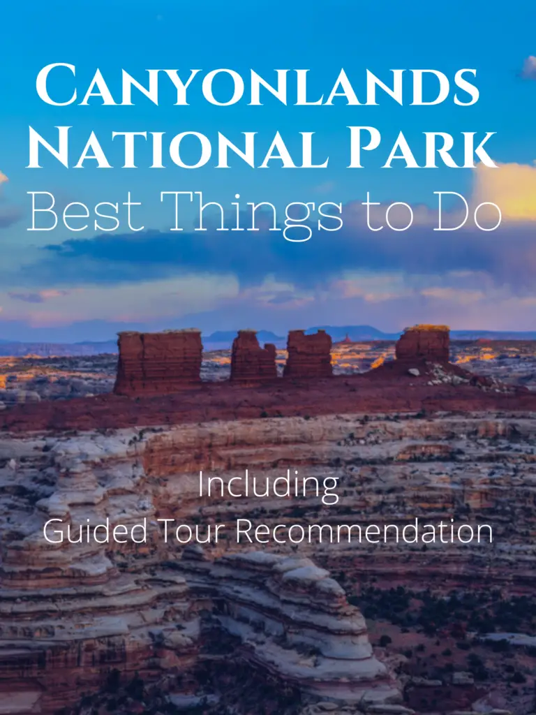
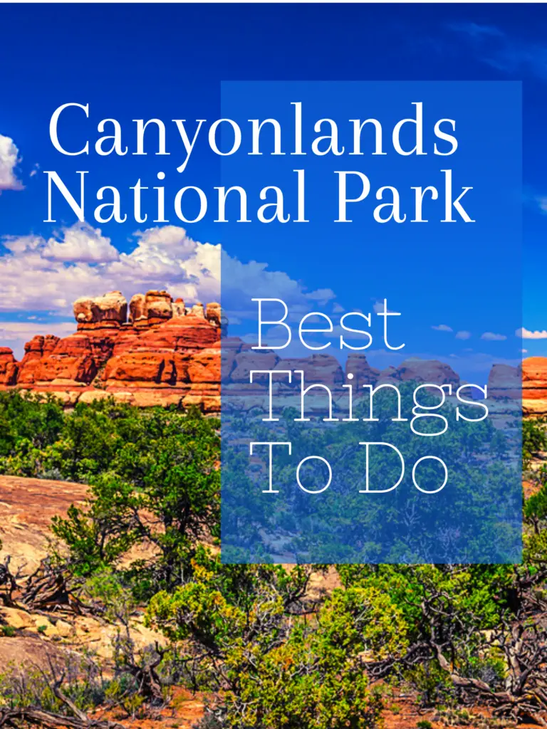
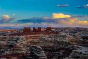
Canyonlands is the largest of Utah’s five national parks. Its 330,000 plus acres is so expansive and diverse that the park is divided into four areas known as districts.
The Island in the Sky district is 30 miles from Moab. It is the most visited since the lookouts and some of the sites can be reached by most vehicles.
The Needles district is 60 miles from Moab. Some of the highlights can be explored in a single long day. But it is recommended to schedule much more time. Also, the backcountry roads require a high-clearance 4×4 vehicle.
The Maze district is 150 miles from Moab, is much more remote, and requires a high-clearance 4×4. Once visitors reach the entrance to the Maze district, they are often surprised to find out that reaching the most popular hikes and rock formations requires hours more drive time.
The Rivers district is not always apparent when viewing a map. This district refers to the more shady and green areas located way down deep in canyons that were carved out by the powerful Colorado and Green Rivers.
The rivers can be accessed by boat only from outside the park. Except for a few shuttle companies allowed to offer boat and kayak services inside the park.
Moab, UT is one of the best places to find lodging, restaurants, provisions, and 4×4 rentals. The downtown area of Moab is a great area to enjoy and explore. And the fabulous Arches National Park is just a 5-mile drive away. I could live here!
My list of the best things to do in Canyonlands begins with the best things to do in the Island in the Sky district. The sites are listed in order of ease of access from the visitor center.
My list then moves to a scenic byway just outside the park between Canyonlands and Moab.
Then I list information related to the more remote regions of Canyonlands.
Table of Contents
Shafer Canyon Overlook and Shafer Trail Viewpoint
The Shafer Canyon Overlook is located just south of the Island in the Sky Visitor Center. This is a great place to start as it offers views of the steep and narrow winding Shafer Road leading to the deep canyon and sites below.
From this overlook, walk the short Shafer Trail for closer views of the canyon. The trail is easy but not for those with a fear of heights. No guardrails.
Note: For those planning to drive down the winding Shafer Road, the access point is just 1.5 miles north of this overlook.
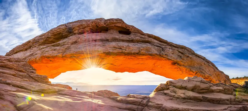
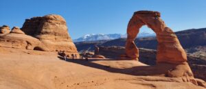
Mesa Arch Loop Trail
Continue south from the Shafer Canyon Overlook to the Mesa Arch Loop Trail, one of the most popular hikes in Canyonlands. Access the .5-mile loop trailhead from the parking area.
Sunrise views and photo ops make this area somewhat busy year-round. But it is so worth navigating the crowd to experience a great view through the “window” of the arch. I love this view so much.
Buck Canyon Overlook
From Mesa Arch, continue south 3.5 miles for a quick stop at Buck Canyon Overlook. Many skip this viewpoint but I recommend taking in the canyon views from this unique vantage point.
Grand View Point Trail and Overlook
From Buck Canyon Overlook drive 3 miles to reach the southernmost point along Island in the Sky scenic drive.
Take a short, paved path to the first viewpoint. At over 6,000 ft. views from here extend to the Needles district. And this is a great area to learn from park rangers and information markers about the area’s geology.
If you have only a short time to visit Canyonlands, make this viewpoint #1 on your list.
If time allows, take the 2-mile out and back trail. You won’t be disappointed. There are no guardrails and parts of the trail runs along sheer cliffs. But the trail is fairly flat and leads to a view of the iconic dinosaur-track-shaped carved-out canyon. With the Colorado River to the east and the Green River to the west visitors get a real sense of the significance of the park’s name.
Now for the really good stuff! Where winding roads get rugged, steep, and narrow.
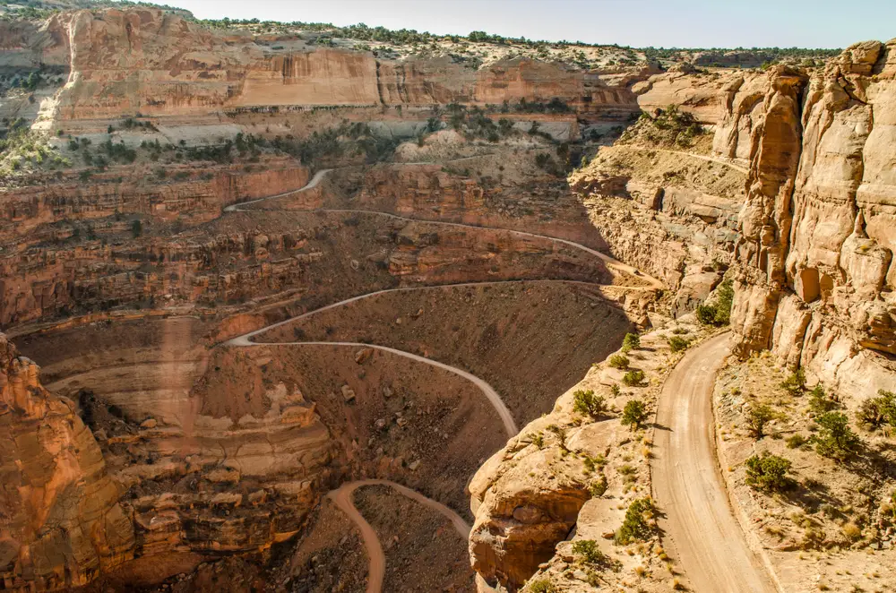
Shafer Trail Road
From Grand Viewpoint, backtrack for about 12 miles along Island in the Sky scenic drive.
1.5 miles past the visitor center is the access point to Shafer Trail Road. This is the intimidating narrow rock and dirt road that winds 5 miles down to the canyon.
Traveling this road is a harrowing adventure. But I loved it!
Not for the faint of heart. Take it easy and take it slow.
Note: Cell service gets spotty in the canyons so download a map or pick up a copy at the visitor center before proceeding.
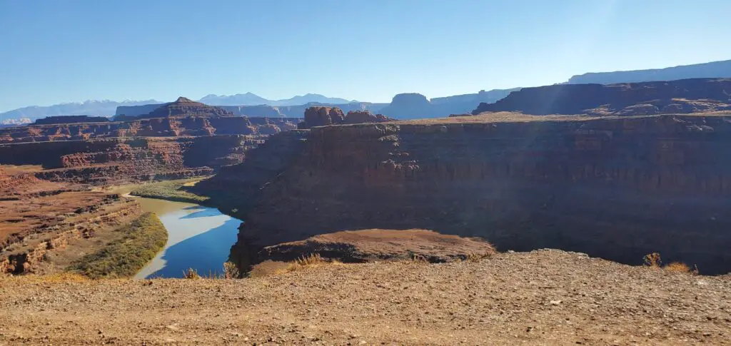
Gooseneck of the Colorado
Traveling down Shafer Trail Road from the visitor center, take the fork to the right onto White Rim Road.
About 1.4 miles ahead is an incredible view where the Colorado River takes an abrupt U-turn. Spend a little time here to fully take in this spectacular view.
Pro Safety Tip: Looking straight down over sheer cliffs can be scary and dangerous. To avoid feelings of vertigo while capturing a photo, consider dropping to your knees, then laying prone on your stomach to take in the views below.
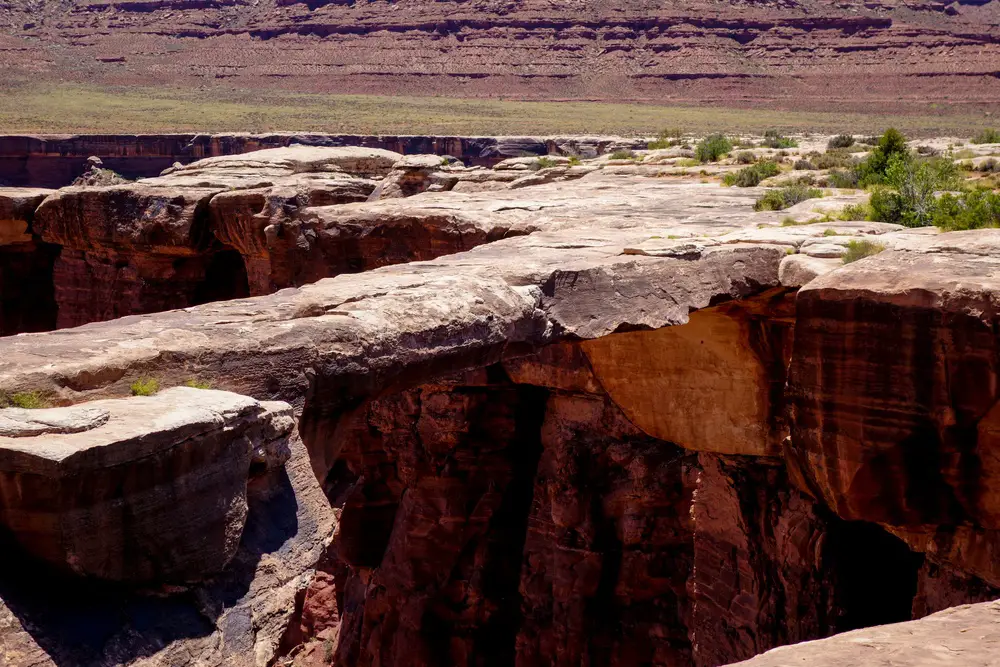
Musselman Arch
Continue 2 miles south on White Rim Road to take a short walk to Musselman Arch.
Though massive, visitors often have a hard time locating the arch. Because it’s flat and at footpath level.
Walking up to the arch feels fairly uneventful until you reach the edge to see the drop-off on either side.
It was hard for me to believe the arch is still standing due to its narrow width when compared to its length.
Pro Safety Tip: Walking out onto the arch is dangerous as the narrowest point is only 3 feet wide. Also, notice the flaking away on the underside.
Thelma and Louise Point
From Musselman Arch, backtrack about 4.5 miles to the fork at Shafer Trail Road and Potash Road.
Take Potash Road to the right for 4 miles. Here you will find the towering Dead Horse Point to the north and an overlook of the Colorado River below to the south. This is Thelma and Louise Point.
This overlook is the film site of the closing scene of Thelma and Louise where a convertible Thunderbird goes sailing over the canyon.
For more movie trivia, simply look to the north to view the towering Dead Horse Point above. This is the film site of the opening scene of Mission: Impossible 2 where Tom Cruise climbs and jumps along the rock face.
I love visiting iconic film sites!
Pro Tip: The highest point of Dead Horse Point can be reached by driving to the nearby Dead Horse Point State Park. Views from the overlook here are other-worldly.
From Thelma and Louise Point, I recommend continuing east for 10 miles along Potash Road. Keep an eye out for big-horned sheep and Elvis Rock as you drive past private evaporation ponds and a manufacturing site.
You will be leaving Canyonlands and Potash Road becomes paved and continues along Hwy 279 to Moab.
Potash – Lower Colorado River Scenic Byway (Hwy 279)
Turning onto Potash Road/Hwy 279, follow this 17-mile scenic road straight to Moab after a long day of exploring.
Or take anywhere from a half day to a full day to explore the various sites along the byway.
Sites include close-up views of the Colorado River, soaring sandstone cliffs, short hikes to dinosaur tracks, rock art, and arches, roadside rock climbers, cycling trails, and jeeps traversing steep slopes.
Here are a few of the best things to do along the Potash–Lower Colorado River Scenic Byway.
Corona Arch and Bowtie Arch Trail
From the beginning of the paved section of Potash Road drive 5 miles alongside the Colorado River. Watch for signs to Corona Arch and Bowtie Arch. This is a fun well-marked out and back 3-mile trail for both kids and experienced hikers.
Along the trail to impressive arches, enjoy building cairns (stacked rocks), climbing a small ladder, and scaling moderately steep slopes with the assistance of safety cables.
Poison Spider Dinosaur Track and Poison Spider Mesa Trail
From Corona and Bowtie Arch, drive 4 miles to turn at the Dinosaur Track and Poison Spider Trail road signs. The parking area is on the right.
Walk to the right of the toilet to take the fun little .2-mile trail to view information markers, dinosaur tracks, and rock art. This is a fantastic little hike and mini outdoor museum.
This little hike offers THE BEST experience for very little effort.
For those with the time, and an adventurous spirit, check out the popular 13-mile Poison Spider Mesa Trail. Runners, mountain bikers, hikers, and 4×4’s share this rugged adventure. Watching the jeeps outfitted for climbing is entertaining and a bit terrifying.
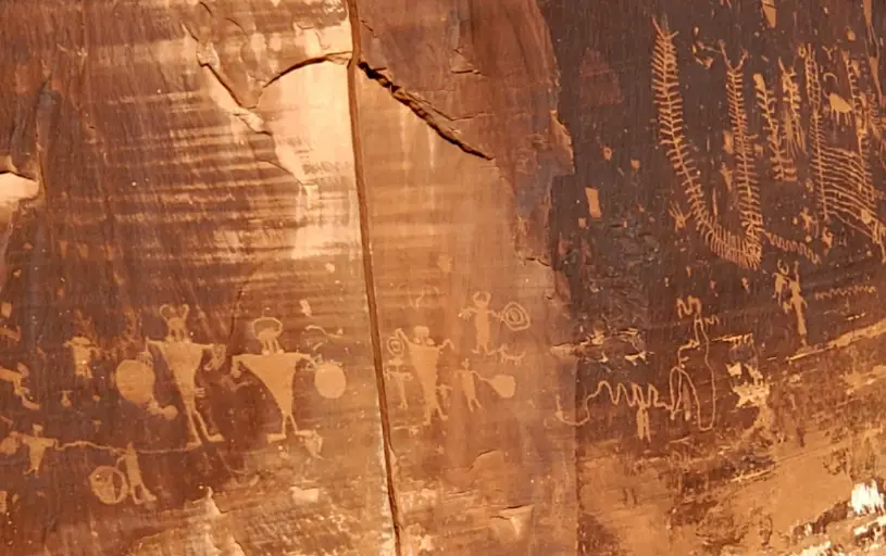
Petroglyphs and Pictograph
Follow Potash Road about 1 mile further and pull over at the Indian Art sign. No detour or hike is required as several rock art panels can be seen from the road. These Native American petroglyphs and pictographs are estimated by Archeologists to date back to between 6,000 B.C. and 1,300 A.D. They are fantastic.
Rock Climbing
Continue along Potash Road a short way to view rock climbers at the “Wall Street” section of this narrow gorge. Use caution as this stretch of road is often congested with climbers and onlookers.
Needles District
The Needles district sets adjacent to the Island in the Sky district, though there are no connecting roads. So expect the drive to take about 1.5 hours from Moab.
To fully experience the Needles district, a 4×4 vehicle outfitted for rugged terrain is required. There are plenty of places to rent technical vehicles in Moab. If you are less experienced and want to explore the backcountry, I recommend booking a guided tour.
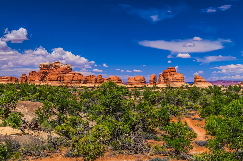
The Needles is named for its colorful spires of Cedar Mesa Sandstone. The sandstone formations are unique yet quite similar to the hoodoos of Bryce Canyon National Park.
The Needles is full of rough jeep trails and 74 miles of hiking trails leading to incredible sites.
Chesler Park
If you don’t have a lot of time in the Needles and want to pack a lot into a single hike, Chesler Park is the place.
It is a somewhat difficult 10-mile hike with 2,100 ft. elevation gain. Expect for the entire hike to take 5-7 hours. And, of course, bring lots of water and provisions.
The trail is well-marked with cairns. And at each intersection, there are markers directing to off-shoot trails and distances.
Joint Trail
Joint Trail is a highlight of Chesler Park. It includes a dense collection of sandstone spires, a narrow rock staircase into a cave, and a slot canyon. What more could you ask for?

Maze District
The Maze district sets adjacent to the Island in the Sky district as well. And there are no connecting roads between.
The Hans Flat Ranger Station is the gateway to the Maze and is about a 5.5-hour drive from Moab.
The nearest lodging options can be found in Hanksville or Green River. Hanksville is a 2-hour drive from the ranger station, and Green River is a 2.5-hour drive. But, once you reach the Hans Flat Ranger Station, the canyons of the Maze are another 3-6 hour drive by high clearance 4×4 vehicle.
Visiting the Maze takes preparation for self-sufficiency. And time. Several days-worth.
The park is full of steep grades, drop-offs, and paint-scaping narrow passages. So, make realistic plans as stranded visitors can pay up to $1,000 for towing services.
The Maze is named for its deep intricate labyrinth of canyons and is known as the wasteland where Butch Cassidy and The Hole in the Wall Gang hid out.
Some of the most well-known sites to journey to include:
Roberts Roost High Spur Canyon
For experienced cannoneers, this slot canyon is touted as one of the best and most picturesque.
Chocolate Drops
Chocolate Drops rock formations are four somewhat rectangular columns rising to 200 feet. The drops can be seen from the Maze Outlook. Or take the 7.5-mile out and back trail for an up-close look.
Flint Trail and Dollhouse Trail
Flint Trail is a difficult jeep trail leading past several unique and named rock formations. Flint Trail connects to Dollhouse Trail and views of the Dollhouse rock formations. A difficult 2.8-mile out and back hiking trail leads “inside” the Dollhouse.
Elephant Hill
Elephant Hill is one of the most technical roads in Utah presenting drivers and bikers with steep grades, stair-step drops and tight turns. So tight that some points can be navigated only in reverse.
Rivers District
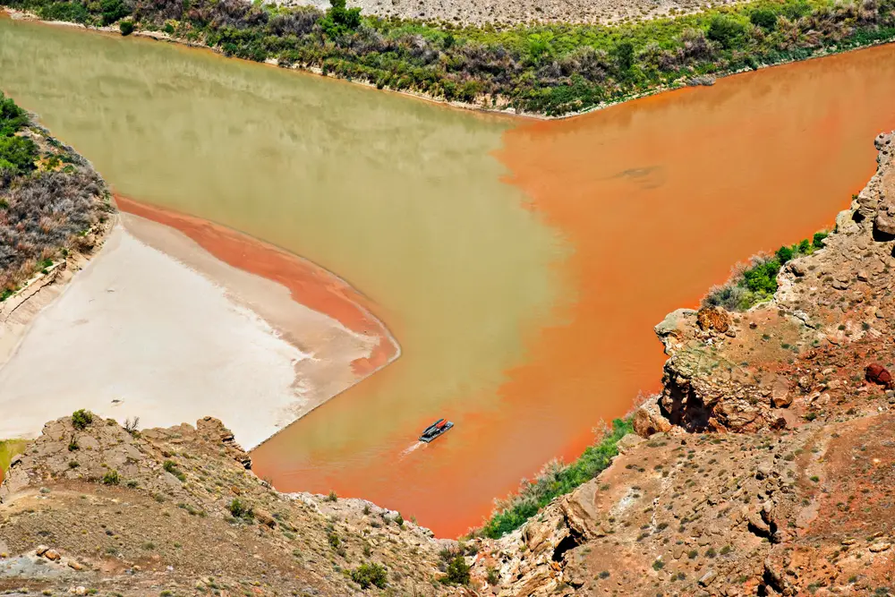
The Rivers refers to the two rivers, the Green and the Colorado, that carve through the park and merge at a spot known as the Confluence.
This district of deep canyon walls is much more green, shady, and full of life in contrast to the park’s other districts.
The rivers and surrounding ecosystems created by the powerful rivers and lush and green river-bank environments can be viewed from the other three districts which are located high above the canyon walls.
The more adventurous can experience the Colorado River and the Colorado Plateau in a Rigid Hull Inflatable Boat (RHIB). The Cataract Canyon area offers one of the top rafting adventures in America, with 14 miles of flat water leading through Class III to V rapids.
Hiking trails lead to the rivers from each of the other three districts. The trails are very rugged and long so they are not realistic options for launching unless visitors are experienced and equipped with packrafts.
Public boat and kayak launch ramps to the Colorado and Green rivers are located outside the park’s boundaries. Launch sites include Potash ramp, Moab ramp, Green River State Park, Ruby Ranch, and Mineral Bottom.
See the Canyonlands National Park website for a few companies licensed to provide river shuttles inside the parks.
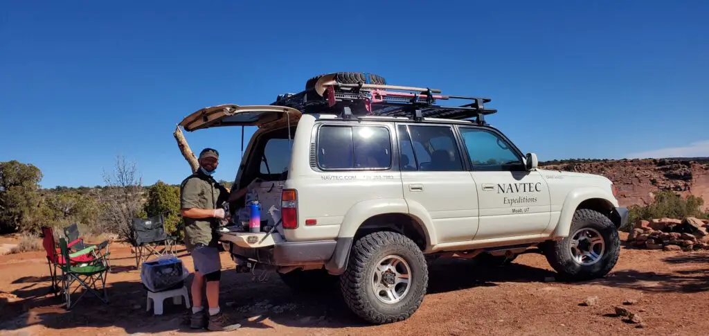
Guided Tours
Most of the park’s arches, mesas, and colossal canyons are reached by crossing rough terrain and pitted jeep trails.
So I chose a guided tour to various Island in the Sky district highlights including a few of those mentioned above.
The guided tour included information about the area’s geological and early pioneer history. All while riding in a comfortable and technical Landcruiser driven by a capable and knowledgeable guide.
One of my favorite off-the-beaten-path sites was the Willow Springs Dinosaur Track Site. Here we viewed a series of what archaeologists believe to be footprints made by a prehistoric three-toed dinosaur.
Now, For A Bit of Canyonlands National Park History
In 1949 nearby Arches was an obscure national monument with no paved roads. But during the almost 35-year tenure of the tenacious monument superintendent, Bates Wilson, all that changed.
By his retirement in 1972, he had worked to double the size of Arches and it became a popular National Park.
Also, while superintendent at Arches, Wilson worked to create a national park in the area surrounding the confluence of the Green and Colorado rivers. He coaxed government officials to the area by offering tours that included campfire conversations and dinners cooked over the flames.
His efforts were realized on September 12, 1964, when President Lyndon B. Johnson signed into law the establishment of Canyonlands National Park. And Bates became its first superintendent, earning him the title of “Father of Canyonlands.”
A Few Things to Remember
Permits are required to visit many areas of Canyonlands. See the park website for more information.
Check the weather before you go. Canyonlands National Park has what is known as a high desert climate. Temperatures can vary by 40 degrees in a single day and each district of Canyonlands has its own unique weather.
Overall, summers are hot and temperatures usually exceed 100 degrees with late summer storms leading to flash flooding. The shoulder seasons are pleasant but short, and though snowfall is rare in winter, temperatures can range from cool to freezing. Be aware that ice can cause trails and roads to become impassable.
During my time exploring Canyonlands, I got a lot of use out of my Ahnu hiking shoes. They are lightweight for everyday use which is helpful when I want to travel with only a few pairs of shoes.
One of my favorite backpacks is the ultralight Osprey Talon Series. I happen to like the Talon 11, especially due to the extra soft frame padding and overall design.
Travel insurance covers unexpected events such as re-booking flights due to airline cancellations, replacement of belongings when luggage is lost, replacement of stolen items, or emergency travel home due to accident or illness. I recommend World Nomads, an insurance provider trusted by seasoned travelers worldwide.
Also, check out my road trip packing list.
To expand your adventure beyond Canyonlands National Park, see my Utah National Parks Mighty Five Road Trip Guide.


17 thoughts on “Best Things To Do In Canyonlands National Park”
Loved reading the post. All the photos are incredible.
Thank you!!!
I’m so happy to have come across your article because I feel like Canyonlands Nat’l Park doesn’t get the attention it looks like it deserves! Love all your photos and how you broke down the various districts and lookout points. This post was so helpful!
Thank you! I agree that Canyonlands doesn’t get the attention it deserves. It is an incredible park.
I did a Utah road trip a few years back with my friend. We flew into Vegas then drove to visit Zion, Bryce, Coral Pink sand dunes, Antelope Canyon, & the Grand Canyon. It’s a shame we weren’t able to make it to Canyonlands. But we’re planning another NP road trip for this summer! Thanks for the detailed guide!
You made it to some great areas! I hope you make it back to Canyonlands!
What a beautiful looking place to visit. Can’t believe it can change in temperature by 40°!
I know! Definitely a place for layering.
This looks like such an amazing national park to tour around! You can definitely get a lot of great photos here.
It is truly amazing.
Beautiful pictures, Tracy! I love seeing my friends having Grand Adventures in Life!
Michelle!!! Thank you! I was just thinking of you a few days ago!
Wow! That is such an elaborative list. I loved it. Keep up the awesome work, Tracy.
Canyonlands looks absolutely beautiful! I need to get back to Utah and visit this park. I only did Zion and Bryce when I did my road trip last year. Your photos are so beautiful. 🙂 Great guide!
We love love love Canyonlands. Did Druid Arch last month and drove the full white rim trail back in January. These are some great tips 🙌🏻
One of the spots in Utah I’ve always wanted to go to!
Just got back from Utah and spent two days in Canyonlands. I SO wish I’d had 4WD – I made it deep into the Needles on foot, but I wanted to try backpacking in the Maze too, and there was just no way that was going to happen with a rental car. Unfortunately it was 105 degrees and sunny the day I was in Island in the Sky, so I didn’t enjoy it that much lol.